
The rain is gone, the humidity is dropping, and a much more comfortable stretch of early October weather is settling into Metro Detroit.
Behind Friday morning’s cold front, cooler and drier air continues to move into Southeast Michigan. Afternoon temperatures topped out in the mid-60s around Detroit.
Skies clear out Friday night as high pressure builds into the Great Lakes. That will allow temperatures to fall quickly after sunset.
Friday night football turns chilly
High school football games Friday evening should stay dry.
Temperatures around Romeo are near 60 at kickoff, then fall into the mid-50s by halftime and near 52 by the drive home.
That means fans will likely want an extra layer, especially once the sun goes down.
Detroit is expected to drop into the mid-40s overnight, but some western and northern communities could fall into the upper 30s and lower 40s. Lapeer’s low is forecast near 38 degrees, while Flint and Fowlerville fall to around 40 degrees.
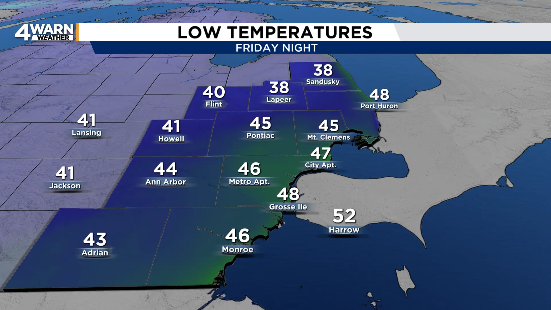
Despite the chilly temperatures, frost is not expected across Metro Detroit. Surface moisture and temperatures should remain just warm enough to prevent frost in most of Southeast Michigan. Frost and freeze alerts are focused farther north across portions of Northern Michigan and the Upper Peninsula.
A cool but beautiful Saturday
Saturday is shaping up to be a classic early-October day.
Expect plenty of sunshine, with cooler-than-normal highs mainly in the lower to mid-60s. Most of Metro Detroit lands around 62 to 64 degrees, including roughly 63 in Detroit, Ann Arbor, Flint, Mt. Clemens and Monroe.
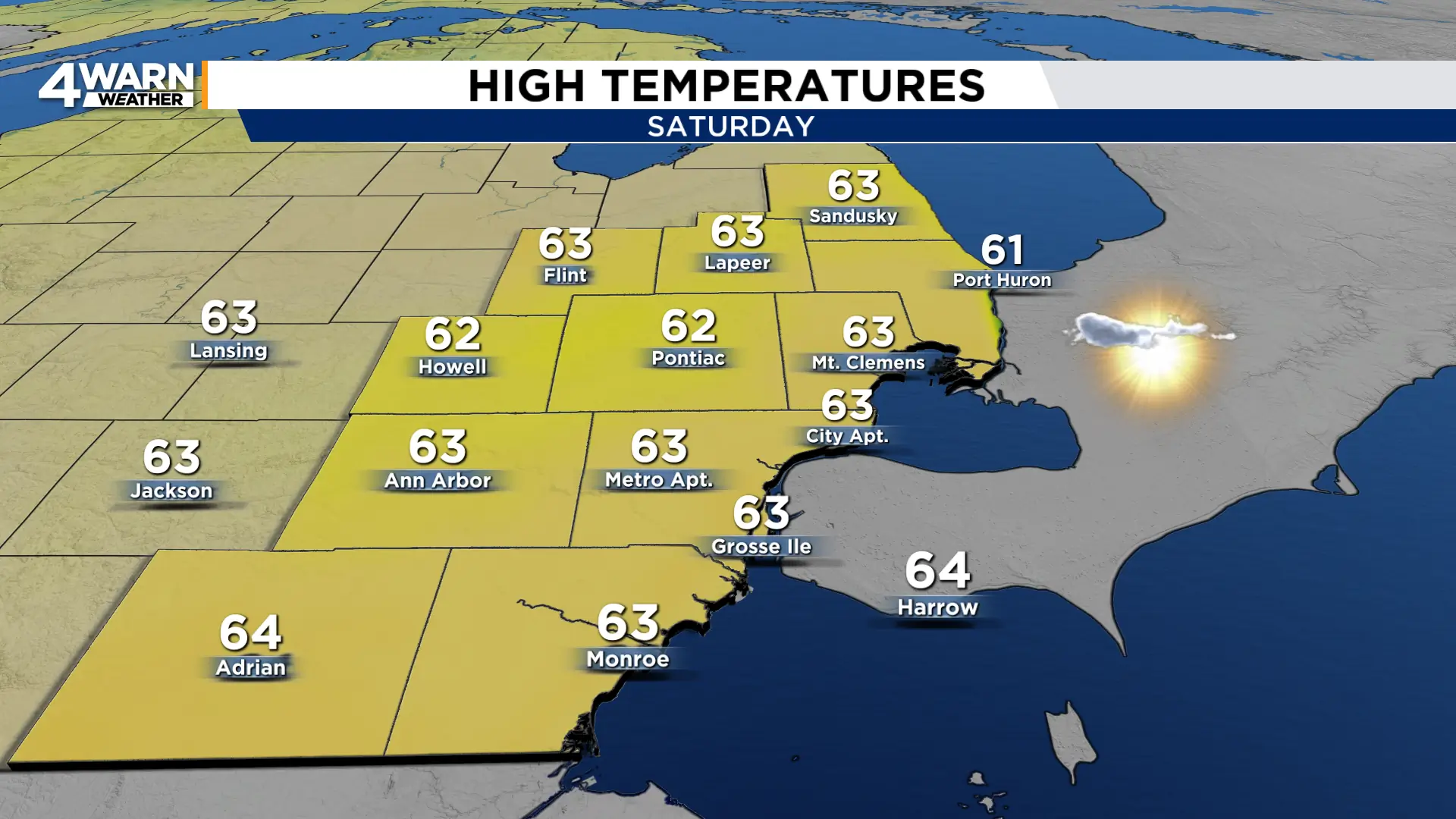
Winds remain light, which should make the cooler temperatures feel comfortable in the sunshine.
It is also good weather for outdoor events such as Detroit Harvest Fest at Ralph C. Wilson, Jr. Centennial Park. Temperatures will be cool, but with mostly sunny skies, sunglasses may be useful.
A light jacket or sweatshirt will also be a good idea, especially during the morning and evening.
Sunday turns warmer
Sunday is the warmer and more seasonable day of the weekend.
Highs rise to near 70 degrees across Metro Detroit, with mostly sunny skies expected through the day.
There is a low chance of a spotty shower late Saturday night into early Sunday morning, but the better chance stays well north of Metro Detroit, closer to Saginaw Bay and the Thumb.
For most of Southeast Michigan, Sunday will stay dry.
Lions could face rain in North Carolina
While the weather looks quiet at home, the Lions may have wetter conditions for their Sunday night game against the Panthers in Charlotte.
Rain is possible during the afternoon and evening, along with a chance of thunderstorms. Temperatures during the game are expected to hover in the lower to mid-60s.
Kickoff is scheduled for 8:20 p.m.
Cooler again early next week
Another push of cooler air arrives Monday.
Highs fall back into the lower 60s Monday and Tuesday, while nighttime temperatures dip into the 30s and lower 40s in some areas.
Tuesday morning could bring the better opportunity for lows in the 30s, although many locations may remain near 40 degrees.
The pattern stays largely dry early next week before temperatures moderate again. Highs climb back into the upper 60s Wednesday and around 70 degrees by Thursday.
After a wet start to Friday, Metro Detroit heads into a dry, sunny and seasonably cool weekend, with Sunday offering the warmer outdoor weather.
Share your weather photos with Local 4 at MIPics.
